Autonomy: route finding
Route finding is the other 50 points of the Autonomy mission and the part where autonomy either works or does not. Two targets sit at exact coordinates. One is on a hill where not every approach direction is navigable; the other is behind the hill and out of radio line of sight. Each target is worth 25 points and each has a 1 m stop tolerance.
Key takeaways
- This is the all-or-nothing half. Across 162 team-years, 41 % of Autonomy scores are exactly zero, the highest zero rate of any mission S-URC22-SCORES S-URC26-SCORES.
- Exact coordinates make the driving easier and the stop harder. The coordinates remove the need for visual search, while the stop tolerance tightens from 2–3 m in 2026 to 1 m in 2027 S-URC27-QA S-URC27-RULES §1.e.xvii AUQ16.
- The cleanest experiment in the record is Monash. A ground-up rebuild scored 0 in 2024 and 14 in 2025; removing the sophisticated planner and returning to NavFn scored 86 in 2026 S-MONASH-SAR2026.
- The radio link never gates the drive. The second target is designed to be out of line of sight, so one link-status check is a 25-point failure.
What the mission physically demands
| Demand | Number | Basis |
|---|---|---|
| Targets | Two, in any order, with no return required, at exact coordinates | S-URC27-RULES S-URC27-QA §1.e.xii AUQ16 |
| Stop tolerance | Within 1 m of the target, plus an indication of arrival | S-URC27-RULES §1.e.xvii |
| Terrain | Hilly natural terrain; target 1 on a hill where not all approach directions are navigable; target 2 behind the hill and out of radio line of sight | S-URC27-RULES §1.e.xv §1.e.xvi |
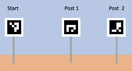
| Markers | Three-sided AR posts with 20 × 20 cm faces, 0.5–1.5 m above ground, ArUco 4x4_50 with 2.5 cm cells and a one-cell white border | S-URC27-RULES §1.e.xii |
| Arrival indication | A rear LED flashing green; a C2 indication is strongly recommended but not required | S-URC27-RULES S-URC27-QA §1.e.ii AUQ18 |
| Map data | URC will attempt a digital elevation model at 1 m resolution, likely GeoTIFF, not guaranteed; satellite imagery is encouraged | S-URC27-RULES S-URC27-QA §1.e.xiii AUQ20 |
| Time | Inside the same 40 minutes as astronaut assistance | S-URC27-RULES §1.e.i |
| Penalties | 20 % for an operator stop, 50 % for teleoperation back over explored ground, capped at 50 % per task; a physical intervention is uncapped, and teleoperation may not enter unexplored ground | S-URC27-RULES §1.e.xviii |
| Stop budget implied | About 0.6 m of the 1 m tolerance allocated to the stop itself | S-URC27-RULES §1.e.xvii, by inference |
| Approach kinematics | 1 m/s at 0.3 m/s² needs about 1.7 m to stop | By inference |
What the best teams did
| Year | Teams | Mean | Median | Exact 0 | Maximum |
|---|---|---|---|---|---|
| 2022 | 26 | 23.9 | 11.2 | 12 | 84 |
| 2023 | 31 | 26.4 | 16.8 | 15 | 96 (Michigan) |
| 2024 | 34 | 23.9 | 5.6 | 17 | 72 |
| 2025 | 35 | 31.5 | 28.0 | 7 | 86 (BYU) |
| 2026 | 36 | 26.7 | 21.0 | 16 | 86 (five teams) |
Derived from the official Autonomous Navigation column in the five result sheets S-URC22-SCORES S-URC23-SCORES S-URC24-SCORES S-URC25-SCORES S-URC26-SCORES. Michigan’s 96 in 2023 is the window maximum.
- Missouri S&T sat at 56 for three seasons, then reached 86 in 2026 with satellite terrain data and LiDAR planning S-MST-SITE-ATHENA S-URC26-SCORES.
- Monash went 0 (2024), 14 (2025), 86 (2026). The 2026 fix was removing a state-lattice planner in favour of NavFn with a voxel costmap, after a ground-up rebuild had scored zero S-MONASH-SAR2024 S-MONASH-SAR2026.
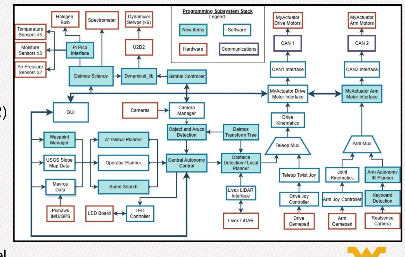
- West Virginia reached 86 in 2026 with A* over USGS elevation data, a Livox Mid-360 with FAST-LIO, and local traversability planning S-WVU-SAR2026.
- Michigan reached 96 in 2023 after a microservice rewrite, then scored 56, 56 and 86 S-URC23-SCORES S-URC26-SCORES.
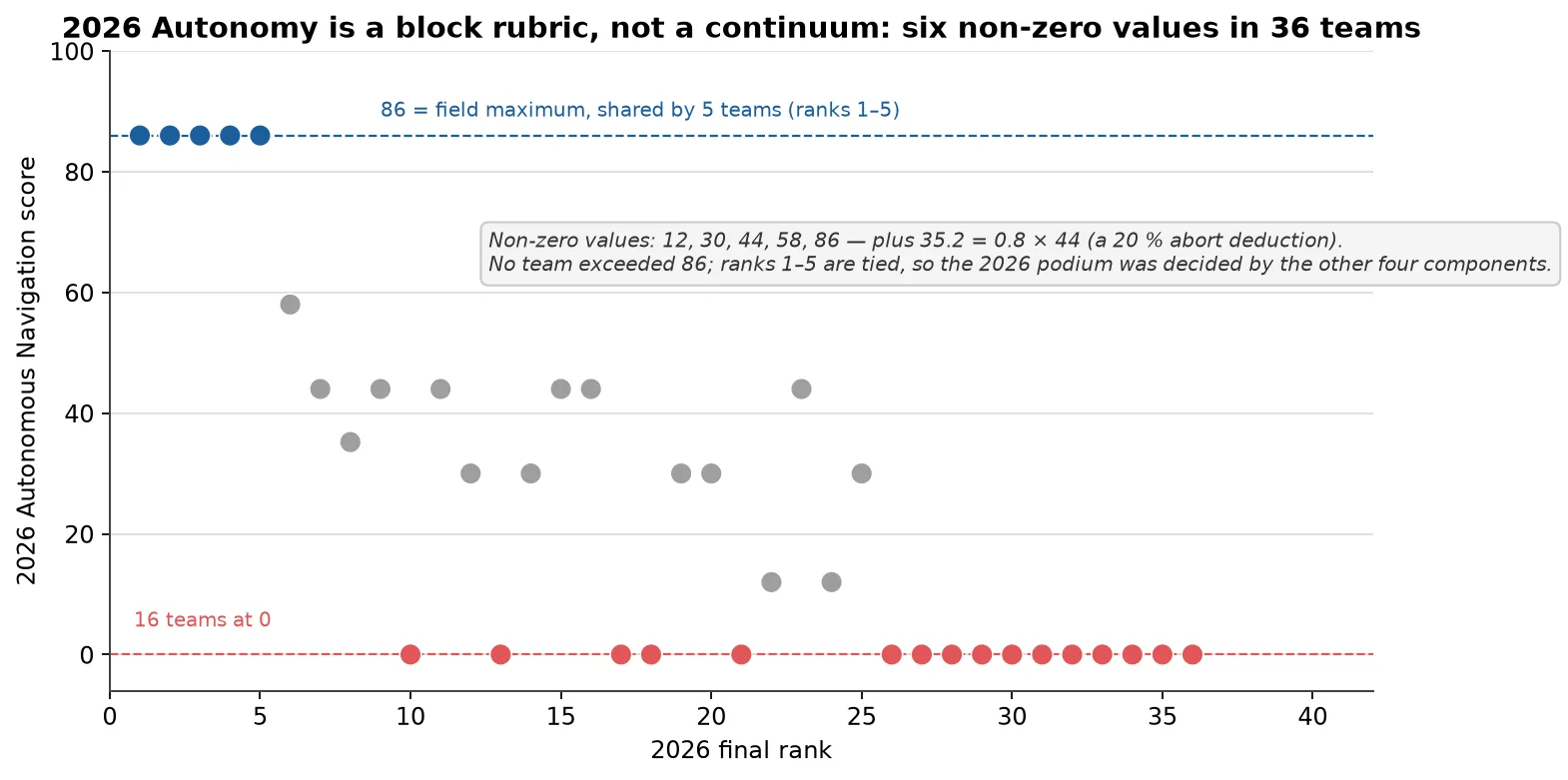
The same values as an interactive chart:
The transferable lesson. Each of the three teams that document their planning stack in detail used a terrain map, from an elevation model or from LiDAR, with a conservative planner. The team that moved from sophistication to conservatism gained 72 points. The map data is worth buying, the planner is worth keeping boring, and the effort belongs on the terminal stop.
Does 2027 invalidate it
Partly. The AR-post geometry is unchanged S-URC26-RULES S-URC27-RULES §1.f.iv §1.e.xii, and exact coordinates make the navigation easier, but three things tighten at once.
| Element | Status | Verdict |
|---|---|---|
| AR-post detection and terminal servoing | Same tag library and cell size | Carries forward |
| GNSS waypoint navigation | Still the backbone, with coordinates now exact | Carries forward, easier |
| Stop tolerance | From 3 m at a GNSS point and 2 m at a post in 2026 to 1 m | Raised bar |
| C2 arrival display | The LED is now sufficient and the C2 banner optional | Easier |
| Hill route where not all approaches work | New emphasis, with no published inclinations | Raised bar |
| Second target out of radio line of sight | New, and not deliberately tested in 2025 or 2026 | New |
| Penalty exposure | 20 % for an operator stop, 50 % for teleoperation, capped at 50 % per task | Raised bar |
| Mission structure | 30 minutes, a 2 km cap and five target classes became 40 minutes and two targets | Invalidated as a mission, valid as a stack |
Which subsystem options serve it
| Decision | Option A applies when | Option B applies when |
|---|---|---|
| Localisation | Dual-antenna RTK with a dual Kalman filter, wheel odometry and a magnetometer, because heading error dominates once the rover is more than 10 m from the last fix | Single-antenna RTK with inertial heading; accept 2–4° of error and drive slower near targets |
| Map | A USGS 3DEP elevation model at 1 m resolution turned into a slope costmap, which is available now; treat the URC model as a bonus | Onboard voxel obstacle avoidance where the model is missing or rocks are smaller than 1 m |
| Global planner | A lattice planner over the elevation costmap for a non-holonomic skid-steer rover | NavFn when compute is limited, which is what Monash used in its 86-point year |
| Local planner and speed | Regulated pure pursuit at 1.0 m/s or less, a 2.5 m lookahead, and a terminal approach at 0.3 m/s or less | A sampling controller only with a GPU and time to tune it |
| LiDAR | A Livox Mid-360, or none, added once GNSS and stereo already work | No LiDAR in the first season if the stack is not end to end, because extrinsics, time sync and mapping are the failure modes a first build cannot absorb |
| Visual mapping | Skipped in the first season, because the targets are exact coordinates | Added only where the rover must cross a long GNSS shadow |
| Communications for the shadow | A 900 MHz recovery band carrying a low-rate heartbeat and drive commands | A rover or drone relay, which is allowed but unproven by any team in the sample |
| Behaviour | A behaviour tree with three to five custom nodes for the mode LED and task start and end | A hand-written state machine, written as an explicit table rather than nested conditions |
| Arrival | An LED on the authoritative mode topic, flashing green at 2–4 Hz, with a sunshade and a noon test | A C2 banner in addition, which is recommended but not required |
Minimum viable versus stretch
- The minimum that scores: one target within 1 m. With exact coordinates, a good RTK fix and a terminal-stop discipline, that is achievable without terrain intelligence, provided the chosen target’s approach is navigable. Any order is allowed, so the easier target can go first.
- Partial credit is the safety net and it is unpriced. The rule gives partial points for autonomously completing part of the route, at a rate that is not published. A rover that stops and holds may earn something; a rover teleoperated back earns 50 % at best and may enter no unexplored ground. The failure behaviour should therefore be stop and hold, not call for help.
- The stretch: both targets, including the one out of sight, inside the shared 40 minutes and with the astronaut sub-mission already complete.
Risks to retire early
| Risk | Why it is real | The test that retires it | Lead time |
|---|---|---|---|
| Overshoot past 1 m | 1 m/s at 0.3 m/s² needs about 1.7 m to stop, and no published hit rate exists | Thirty runs around a surveyed point with a terminal approach at 0.3 m/s: 90 % within 1 m and 100 % within 1.5 m | 4 months |
| The link-status check gates the drive | The second target is designed to be out of line of sight S-URC27-RULES §1.e.xvi | Two distinct fault policies, hold for the astronaut and continue and buffer for the route; the rover reaches the target with the radio off | 4 months |
| The planner refuses the only gap | Inflation radius against gap width, for example Monash at 1.28 m S-MONASH-SAR2026 | Inflation at 0.4 times the narrowest intended gap, with a route confirmed on the elevation model rather than in the planning software | 3 months |
| The hill route is not traversable | URC publishes no slope limits S-URC27-QA AUQ17 | An instrumented slope test at 10, 15, 20 and 25° on local analog soil, setting the slope limit from measured slip margin | 4 months |
| A GNSS base offset puts everything 1.1 m off | The base station sets every coordinate the rover uses | A 30–60 minute survey-in on a known point, one base file all week, and logged fix type: repeatability within 2 cm over three sessions | 3 months |
| The judge does not see the arrival LED | The LED washes out in sun S-URC27-QA AUQ3 | A daylight test at 20 m with a sunshade and a 2–4 Hz flash, confirmed by an observer at noon | 2 months |
| An operator aborts to be safe | An operator stop costs 20 % on that task | The rover’s own abort as the default and an operator abort as a logged two-step action: zero operator aborts in 10 rehearsals | 2 months |
| Hands on during autonomous driving | A reflex is the documented failure S-URC27-QA AUQ21 | The autonomy key out of reach and fault-injection drills: zero touches across 10 injected near-misses | 2 months |
| Time runs out across both sub-missions | 40 minutes shared, and the astronaut sequence alone takes about 14 minutes | A timed combined rehearsal with at least 5 minutes of margin, three runs in a row | 3 months |
What is not published
- The partial-credit rate for a partly completed route.
- Whether URC will actually release the 1 m elevation model, which is promised as an attempt only.
- Any slope or step limit for the hill route.
- Whether voice guidance or a beacon-derived position is acceptable during the autonomous drive.
Further reading
- Software stack and autonomy covers the localisation, planner and behaviour choices in more detail.
- Compute, sensors and perception covers RTK, cameras and LiDAR.
- Autonomy: astronaut assistance shares the 40-minute clock and the same localisation.
- Missouri S&T, Monash, West Virginia and Michigan carry the route-finding evidence.
Sources for this page
- S-URC22-SCORESURC2022 Official ScoresOriginal
- S-URC26-SCORESURC2026 Official ScoresOriginal Archived copy
- S-URC27-QAURC2027 Questions & Answers (updated through 2026-10-11)Original Archived copy
- S-URC27-RULESUniversity Rover Challenge 2027 – Requirements and GuidelinesOriginal Archived copy
- S-MONASH-SAR2026Monash Nova Rover, URC SAR 2026 (video, 5:09)Original
- S-URC23-SCORESURC2023 Official ScoresOriginal
- S-URC24-SCORESURC2024 Official ScoresOriginal
- S-URC25-SCORESURC2025 Official ScoresOriginal
- S-MST-SITE-ATHENAAthena (2026) rover page, compact suspension, 3D-printed wheels, hub motors, STM32/CAN controllers, simulator arm, LiDAROriginal
- S-MONASH-SAR2024Monash Nova Rover, URC SAR 2024 (video, 5:07)Original
- S-WVU-SAR2026Team Mountaineers System Acceptance Review 2026 (rover "Deimos"): tri-modal 2.4 GHz + 5.8 GHz + 70 cm, gimbal camera on antenna mast, 750 m LOS / 164 m NLOS high-noise test, antenna + radio budget linesOriginal
- S-URC26-RULESUniversity Rover Challenge 2026 – Requirements and GuidelinesOriginal Archived copy